Site Record
Metadata
Site Name |
English Camp |
Site# |
45-SJ-24 |
Description |
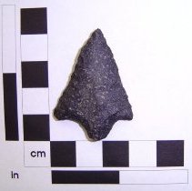
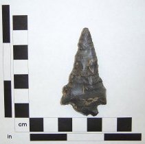
English Camp site is located on the eastern shore of Garrison Bay inside the San Juan Island National Historic Park, English Camp. The site is a deep, highly stratified shell midden with complex layers of whole and broken shells, rocks, charcoal, animal bones, and stone and bone tools. |
Radiocarbon Dates |
500 to 1800 AD |
Notes |
Latitude/Longitude 123.1491°W ( 48°, 35', 11.4" N; 123°, 8', 56.8" W ) The legal description is: Washington, Willamette Meridian T36N,R4W,sec25 UTM zone 10 (X,Y) 489004 , 5381501 The elevation is 34 m ( 112 ft ) The gradient is: 9.2 percent The aspect direction is: 210.5 degrees or SW The local roughness is: 9.5 or moderate The location as decimal degrees (X,Y;Z) = -123.1491, 48.5865; 34 m The state and county are Washington: San Juan County 53055 The HUC is San Juan Islands 17110003; Place point in HUC The Omernik ecoregion is Puget Lowland (more typical) 2 The 1:100,000 map (if available); Switch to TerraServer Zoom on that location with radius = 2 km; 5 km ; 10 km ; 20 km ; 30 km ; custom. |
Legal Description |
Washington, Willamette Meridian T36N,R4W,sec25 |
City |
Friday Harbor |
County |
San Juan |
State |
WA |
Latitude Degrees |
49.0 |
Longitude Degrees |
123.0 |
Elevation in Feet |
112.0 |
Project Name |
San Juan Island Archaeological Project |
Project Type |
Research Project |
Project Year |
1984-1992 |
Principal Investigator/Collectors |
Stein, Dr. Julie K. |
Principal Investigator Affiliation |
University of Washington |
Publications |
Deciphering a Shell Midden. Academic Press. 1992. Exploring Coast Salish Prehistory. University of Washington Press. 2000. |